Trail Road bike Les Angles - les bouillouses au depart lac de matemale - Photo

les bouillouses au depart lac de matemale

 martoche
martoche

User

© OpenStreetMap contributors
Length
Length
48 km
Max alt
Max alt
2021 m
Uphill gradient
Uphill gradient
850 m
Km-Effort
Km-Effort  
59 km
Min alt
Min alt
1561 m
Downhill gradient
Downhill gradient
956 m
Boucle
Boucle
No
Creation date :
2022-07-13 07:09:35.152
Updated on :
2022-07-13 11:18:10.618

(0 Reviews)

Road bike
Road bike
4h07
Difficulty : Difficult

Scan this QR Code to open this trail in the SityTrail application

FREE GPS app for hiking

Logo SityTrail SityTrail

IGN / Geographical institutes

Download SityTrail from the App Store Download SityTrail from Google Play

Logo SityTrail SityTrail World

The world is yours!

Download SityTrail from the App Store Download SityTrail from Google Play Download SityTrail on Huawei AppGallery

About

Trail Road bike of 48 km to be discovered at Occitania, Pyrénées-Orientales, Les Angles. This trail is proposed by martoche.

Description

montee soutenue pendant les 13kms pour atteindre les bouillouses.Apres les Angles vue magnifique sur le lac de matemale.

Elevation profile

Positioning

Country:
France
Region :
Occitania
Department/Province :
Pyrénées-Orientales
Municipality :
Les Angles
Location:
Unknown
Start:(UTM)
424057 ; 4714515 (31T) N.

Trails nearby

Trail Snowshoes Les Angles - Lac d Aude -Refuge Bernardi les Angles - Photo
Snowshoes
MarieFrancoise

Snowshoes

Medium
(1)
Les Angles, Occitania, Pyrénées-Orientales, France
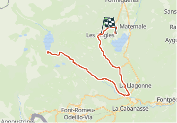
13.9 km | 19.1 km-effort
5h 44min
Yes
Trail Walking Les Angles - lac d'Aude  - Photo
Walking
GUIDE
nadinebondoux

Walking

Medium
Les Angles, Occitania, Pyrénées-Orientales, France
13.8 km | 0 m-effort
5h 57min
Yes
Trail Walking Les Angles - Lac d'Aude en boucle - Photo
Walking
GUIDE
nadinebondoux

Walking

Medium
Les Angles, Occitania, Pyrénées-Orientales, France
13.8 km | 19.9 km-effort
6h 8min
Yes
Trail Walking Les Angles - les Angles - Photo
Walking
GUIDE
nadinebondoux

Walking

Difficult
Les Angles, Occitania, Pyrénées-Orientales, France
14.5 km | 20 km-effort
4h 58min
No
Trail Walking Formiguères - Les Camporells par la Lladure  - Photo
Walking
jcmartin

Walking

Medium
(1)
Formiguères, Occitania, Pyrénées-Orientales, France
15.1 km | 24 km-effort
5h 7min
Yes
Trail Snowshoes Les Angles - lac d aude - Photo
Snowshoes
xav34830

Snowshoes

Very easy
(2)
Les Angles, Occitania, Pyrénées-Orientales, France
14.5 km | 20 km-effort
Unknown
Yes
Trail Walking Les Angles - boucle de la Balmette par le mont Llaret et le roc d'aude - Photo
Walking
Axelloceane

Walking

Medium
(2)
Les Angles, Occitania, Pyrénées-Orientales, France
17.2 km | 28 km-effort
Unknown
Yes
Trail sport Formiguères - 20240728 Station Formiguères - Camporeils - Photo
sport
ThonyM

sport

Very easy
Formiguères, Occitania, Pyrénées-Orientales, France
16 km | 27 km-effort
Unknown
Yes
Trail Walking La Llagonne - 2024-01-22 Les bouillouses  - Photo
Walking
eric.mignot

Walking

Difficult
La Llagonne, Occitania, Pyrénées-Orientales, France
10.3 km | 15 km-effort
3h 25min
Yes


Close
My subscriptions